
JANSSONIUS, Johannes & HORNIUS, Georgius (Georg Horn).
Wall Map of The Tribes of Israel (Hornius Map of the Holy Land).
Wall Map of The Tribes of Israel (Hornius Map of the Holy Land).
Stock Code 90663
[c.1652-84].
The map was included in the sixth volume of Janssonius' Novus Atlas, Accuratissimia Orbis Antiqui Delineatio. The same sixth volume, but with a different title was also sold as a separate historical atlas. The atlas was first published in 1652, and the following year a 32 pages long introduction by Georgius Hornius was added to the publication.
It is assumed that the current map was based on an earlier map by Christian Kruik van Adrichem, published circa 1590. Johannes Janssonius expanded Adrichem's map in order to illustrate Hornius' text in his atlas. Consequently, some refer to this map as the 'Hornius Map'.
Georgius Hornius (a.k.a. Georg Horn or Horne) was a German historian, geographer, theologian and professor. In 1649 he wrote a thesis on theology in Leiden, after which he became a professor of History and Geography at Harderwijk and later in Leiden.
Johannes Janssonius was a Dutch cartographer and publisher. He owned several bookshops in Germany, Sweeden and Switzerland. In 1630s he formed a partnership with his brother in law Henricus Hondius, also from a booksellers family and together they published atlases as Mercator/Hondius/Janssonius.
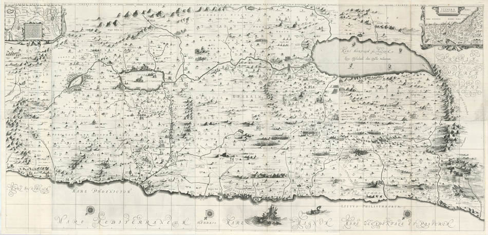
A small in-set map at the upper-left corner depicts Abraham's and the Israelites journey through the desert. The main map is divided to 'Nahalot' (plural of 'Nahala' - meaning inheritance or property in Hebrew - the name of a piece of land that was given to each Israeli tribe). Each Nahala is marked with the name of its tribe. Also many famous biblical scenes can be found on the map, at the presumed place of occurrence: the smoking ruins of Sodom and Gomorra soaking in the Dead Sea; Moses looking across the Jordan River near the entry point of the Hebrews to the land of Milk and Honey (two rays of light coming out of his head); the prophet Elijah departs in his chariot of fire; Joseph's tomb near Beit-El; Samson's fight with the Lion; Samson releasing the three hundred foxes onto the Philistine's land; future King David hiding from King Saul in a cave near Ein Gedi and so on.
Copper engraving, 85 x 179 cm. The complete map comprising 6 parts on 8 conjoined sheets, a very good example. Framed and glazed, overall size: 96cm by 190.5cm.
Koeman 8150:D/1-6.
Couldn't load pickup availability
Provenance
Provenance
Delivery
Delivery
We offer secure and express delivery on all local and international orders of rare books, maps and prints placed through this website.
About us
About us
Shapero Rare Books is an internationally renowned dealer in antiquarian & rare books and works on paper.
Our Bookshop and Gallery can be found in the heart of Mayfair at 94 New Bond Street, where most of our stock is available to view and on public display.
We exhibit at major international art fairs, including TEFAF (Maastricht and New York), Frieze Masters, Art Miami and Masterpiece London, as well as antiquarian & rare book fairs including New York, Paris, London, Los Angeles, San Francisco and Hong Kong.
Ask us a question
Ask us a question


FURTHER READING
View all-

I Explore Therefore I Am
It is strange then that no attention was paid to the accounts of the great epic voyages by the Private Press movement started by William Morris at the dawn of...
Travel & ExplorationI Explore Therefore I Am
The Argonaut PressIt is strange then that no attention was paid to the accounts of the great epic voyages by the Private Press movement started by William Morris at the dawn of...
-

Footprints Across Central Asia | Stein & Hedin
Stein and Hedin were among the great travellers who made significant scientific contributions to Western knowledge of Central Asia, at a time where the area was little explored but hugely...
Travel & ExplorationFootprints Across Central Asia | Stein & Hedin
Explorations in the Early 20th CenturyStein and Hedin were among the great travellers who made significant scientific contributions to Western knowledge of Central Asia, at a time where the area was little explored but hugely...
-

Crossing the Wine-Dark Sea
The epic tale of ancient myths, monsters, and heroes, sung over 2500 years ago by bards in ancient halls, is still being told today. Discover how The Odyssey has been passed down...
LiteratureCrossing the Wine-Dark Sea
Retelling Homer's 'Odyssey'The epic tale of ancient myths, monsters, and heroes, sung over 2500 years ago by bards in ancient halls, is still being told today. Discover how The Odyssey has been passed down...


