
BLAEU, Johannes.
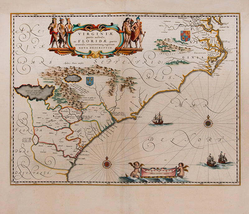
Virginiae partis australis et Floridae partis Orientalis, intrjacentiumqs regionum nova descriptio.
Virginiae partis australis et Floridae partis Orientalis, intrjacentiumqs regionum nova descriptio.
Stock Code 107258
Amsterdam, n.d. [c. 1650].
Hand-coloured double-page engraved map, centre fold as issued, cartouches for the title and scale, Latin text on verso; sheet size: 49 x 56 cm.
Couldn't load pickup availability
Provenance
Provenance
Delivery
Delivery
We offer secure and express delivery on all local and international orders of rare books, maps and prints placed through this website.
About us
About us
Shapero Rare Books is an internationally renowned dealer in antiquarian & rare books and works on paper.
Our Bookshop and Gallery can be found in the heart of Mayfair at 94 New Bond Street, where most of our stock is available to view and on public display.
We exhibit at major international art fairs, including TEFAF (Maastricht and New York), Frieze Masters, Art Miami and Masterpiece London, as well as antiquarian & rare book fairs including New York, Paris, London, Los Angeles, San Francisco and Hong Kong.
Ask us a question
Ask us a question


FURTHER READING
View all-

Footprints Across Central Asia | Stein & Hedin
Stein and Hedin were among the great travellers who made significant scientific contributions to Western knowledge of Central Asia, at a time where the area was little explored but hugely...
Travel & ExplorationFootprints Across Central Asia | Stein & Hedin
Explorations in the Early 20th CenturyStein and Hedin were among the great travellers who made significant scientific contributions to Western knowledge of Central Asia, at a time where the area was little explored but hugely...
-

Crossing the Wine-Dark Sea
The epic tale of ancient myths, monsters, and heroes, sung over 2500 years ago by bards in ancient halls, is still being told today. Discover how The Odyssey has been passed down...
LiteratureCrossing the Wine-Dark Sea
Retelling Homer's 'Odyssey'The epic tale of ancient myths, monsters, and heroes, sung over 2500 years ago by bards in ancient halls, is still being told today. Discover how The Odyssey has been passed down...
-

Iraq in the Early 20th Century
Explore a rare collection of military intelligence guides, vintage photography books, and signed travel accounts that trace Iraq's turbulent journey through the early 20th century, contrasting its ancient heritage with...
Travel & ExplorationIraq in the Early 20th Century
Documenting Life in IraqExplore a rare collection of military intelligence guides, vintage photography books, and signed travel accounts that trace Iraq's turbulent journey through the early 20th century, contrasting its ancient heritage with...


