


HEWETT, Sir John P.
Stock Code 113970
London, His Majesty's Stationary Office, 1919.
Iraq during World War I
Report on the agriculture and infrastructure improvements made by the British in Iraq during the second half of the Mesopotamia Campaign in WWI.The siege of Kut in 1916 during the Mesopotamian Campaign resulted in the single largest surrender of British soldiers to that date, and was considered as embarrassing a defeat as Gallipoli, which had happened not 4 months before. Following the disaster at Kut the British army regrouped, appointed General Maude as the new commander of the army, and started a new offensive in the December of that year. This second offensive of the Mesopotamian Campaign was a resounding success, with Baghdad taken by March of 1917, and most of Iraq up the Tigris occupied. The Armistice of Mudros was signed in October of 1918, ceding most of Iraq, including Mosul, to Britain under the Mandate of Mesopotamia. Just a few years later King Faisal I would be crowned as ruler of Iraq.
British success was in large part due to the major improvements made to the infrastructure of the region thereby keeping the army supplied, which was deemed the cause of the failure at Kut. This report details those institutional and infrastructure improvements made in Iraq by the British, namely improvements in agriculture, transport (particularly canals and railways), the port of Basrah, telegraph and telephone lines, and water supplies. These improvements totalled over £2,000,000, most of which on the port of Basrah and other wharves. The report also recommends further investment in Basrah to help it become the 'great port of the Middle East'.
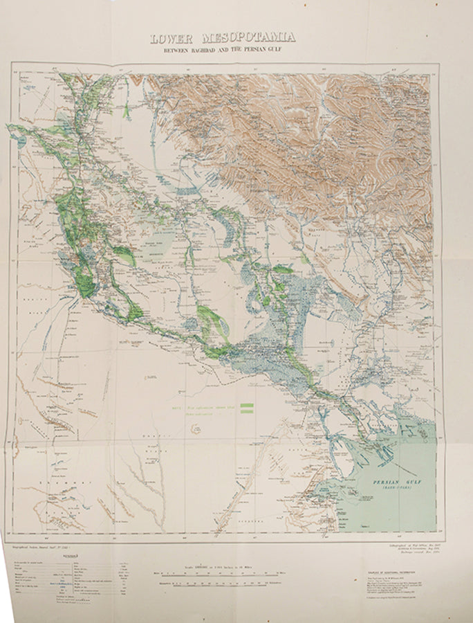
The large map shows most of the lower Tigris and Euphrates, from Kuwait to Baghdad. Highlighted are the richest areas of agriculture, colour-coded as to whether they produce rice or other food, and the waterways are also expanded to show their respective flood plains. Alongside the other infrastructure discussed in the report, such as roads, telegraph lines, railways, and canals, the map also includes labels of areas inhabited by different tribes and groups: Shammar, Albu Muhammed, El Khazail, Rubea, Anaize, Beni Lam, Anifigah, and Ez Zobeid Arabs are some of the groups identified.
This is the publicly published version of this work. The annex lists other maps which it says were 'not reproduced': these have been removed, along with the photographic plates, from the confidential issue of the report.
First edition; 4to (33.5 x 21.5 cm); complete with large folding colour map of Iraq ('Lower Mesopotamia'), scale 1/1,000,000, internally clean; publisher's stapled printed sand wrappers, preserved in a modern protective box, spine and staple-holes professionally restored, staples starting to rust, a very good copy; 72pp.
Couldn't load pickup availability
About us
About us
Shapero Rare Books is an internationally renowned dealer in antiquarian & rare books and works on paper.
Our Bookshop and Gallery can be found in the heart of Mayfair at 94 New Bond Street, where most of our stock is available to view and on public display.
We exhibit at major international art fairs, including TEFAF (Maastricht and New York), Frieze Masters, Art Miami and Masterpiece London, as well as antiquarian & rare book fairs including New York, Paris, London, Los Angeles, San Francisco and Hong Kong.


THE BOND STREET BULLETIN
View all-

Captain Cook's Voyages | The publishing phenomenon
The publishing phenomenon around Captain Cook's Voyages
TravelCaptain Cook's Voyages | The publishing phenomenon
by Tomos NuttThe publishing phenomenon around Captain Cook's Voyages
-

Behind the Door to Room 101
Orwell’s famous adage in joining the working-class cause ‘you’ve nothing to lose but your aitches’ was gloriously ironic for a man with one of the plumiest accents of his age....
LiteratureBehind the Door to Room 101
by Adam BlakeneyOrwell’s famous adage in joining the working-class cause ‘you’ve nothing to lose but your aitches’ was gloriously ironic for a man with one of the plumiest accents of his age....
-

Five Iconic Illustrators Who Transformed Childr...
Meet the illustrators whose distinctive styles helped shape the golden age of children’s books — turning simple stories into unforgettable visual experiences.
Five Iconic Illustrators Who Transformed Childr...
Meet the illustrators whose distinctive styles helped shape the golden age of children’s books — turning simple stories into unforgettable visual experiences.


