
[KNIPE, J.A.].
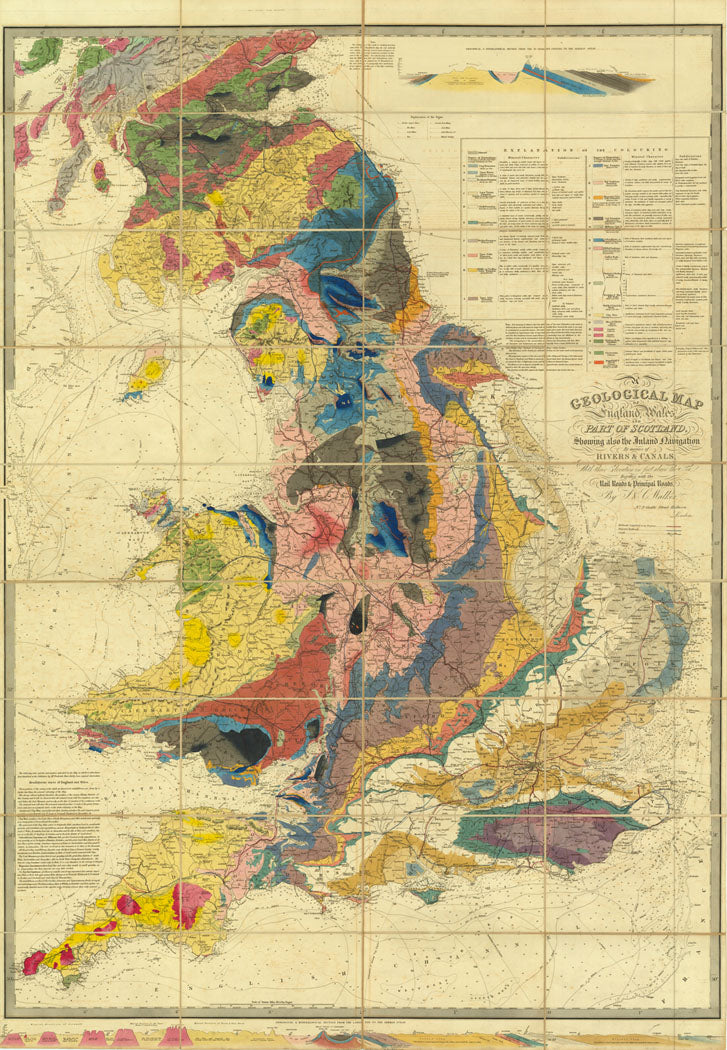
A Geological Map of England, Wales and Part of Scotland
A Geological Map of England, Wales and Part of Scotland
Showing also the Inland Navigation by means of Rivers and Canals with their elevation in feet above the sea together with the Rail Roads and Principal Roads.
Stock Code 78994
London, Published according to Act of Parliament by J. & C. Walker, 9 Castle Street Holborn, Dec., 31st, 1837.
In this printing, the plate was heavily re-engraved, with the original title re-engraved, and an additional section added, extending the map northwards to Forfar.
Along the lower border is a geological section from 'Lands End to the German Sea' (North Sea) and St. George's Channel to the German Sea, with an extensive colour key, 'Explanation of the Colouring', 'Explanation of the Signs' and, acknowledging the times the map was engraved in, a key to 'Railways Completed or in Progress' and 'Projected Railways.'
This was the earliest of Knipe's geological maps; he also produced fine geological maps of Great Britain and Scotland, as well as a second geological map of England and Wales.
Hand-coloured engraved map, dissected and mounted on linen, geological section from 'Lands End to the German Sea' in bottom border, key upper right; without slipcase, some folds torn without loss. Dimensions: 1440 by 1000mm. (56.5 by 39.25 inches).
C.f. BLMC Maps 218.c.4. for 1835 edition.
Couldn't load pickup availability
Provenance
Provenance
Delivery
Delivery
We offer secure and express delivery on all local and international orders of rare books, maps and prints placed through this website.
About us
About us
Shapero Rare Books is an internationally renowned dealer in antiquarian & rare books and works on paper.
Our Bookshop and Gallery can be found in the heart of Mayfair at 94 New Bond Street, where most of our stock is available to view and on public display.
We exhibit at major international art fairs, including TEFAF (Maastricht and New York), Frieze Masters, Art Miami and Masterpiece London, as well as antiquarian & rare book fairs including New York, Paris, London, Los Angeles, San Francisco and Hong Kong.
Ask us a question
Ask us a question


THE BOND STREET BULLETIN
View all-

Captain Cook's Voyages | The publishing phenomenon
The publishing phenomenon around Captain Cook's Voyages
TravelCaptain Cook's Voyages | The publishing phenomenon
by Tomos NuttThe publishing phenomenon around Captain Cook's Voyages
-

Behind the Door to Room 101
Orwell’s famous adage in joining the working-class cause ‘you’ve nothing to lose but your aitches’ was gloriously ironic for a man with one of the plumiest accents of his age....
LiteratureBehind the Door to Room 101
by Adam BlakeneyOrwell’s famous adage in joining the working-class cause ‘you’ve nothing to lose but your aitches’ was gloriously ironic for a man with one of the plumiest accents of his age....
-

Five Iconic Illustrators Who Transformed Childr...
Meet the illustrators whose distinctive styles helped shape the golden age of children’s books — turning simple stories into unforgettable visual experiences.
Five Iconic Illustrators Who Transformed Childr...
Meet the illustrators whose distinctive styles helped shape the golden age of children’s books — turning simple stories into unforgettable visual experiences.


