[STRASBOURG] -
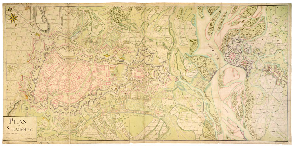
Plan de Strasbourg avec ses environs.
Plan de Strasbourg avec ses environs.
Stock Code 92376
Strasbourg, 1735
The map, dating from 1753, depicts a plan of the French city with the river Rhine running through it, alongside that of the German city of Kehl and markings of nearby castles. It pays tribute to Strasbourg as a historical city, showing the old quarters as well as the medieval fortification wall built in 1412. The map also contains a depiction of the Vauban citadel built between the city and the Rhine in 1681 and designed by one of France's most famous military engineers.
Kehl, depicted on the map, is equally an example of Vauban's work. The city in its entirety, is said to have been designed by him in 1683, following the French take-over in 1678. Kehl was first joined to Strasbourg in 1338 by the bridge seen on the map, although this has since been replaced, and stands as a monument to the changing relationship between France and Germany. It is even said that on one of the small islands between Strasbourg and Kehl, Marie Antoinette was officially handed over to France by Austria in 1770.
Such maps of Strasbourg are rare. We could trace only a similar, very detailed map in Strasbourg's public library, showing to the west a scene of the local justice and to the east the castle of Kehl (BNS, m. caret 10. 686).
Watercolour map on thick paper, the title on a flap. Dimensions: 540 x 1017 mm. Mounted.
Couldn't load pickup availability
Provenance
Provenance
Delivery
Delivery
We offer secure and express delivery on all local and international orders of rare books, maps and prints placed through this website.
About us
About us
Shapero Rare Books is an internationally renowned dealer in antiquarian & rare books and works on paper.
Our Bookshop and Gallery can be found in the heart of Mayfair at 94 New Bond Street, where most of our stock is available to view and on public display.
We exhibit at major international art fairs, including TEFAF (Maastricht and New York), Frieze Masters, Art Miami and Masterpiece London, as well as antiquarian & rare book fairs including New York, Paris, London, Los Angeles, San Francisco and Hong Kong.


