


THUILLIER, Col. Henry Ravenshaw.
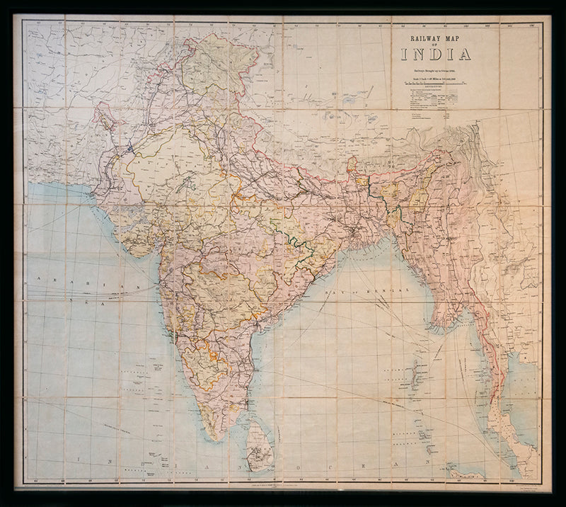
Railway Map of India.
Railway Map of India.
Railways Brought up to October 1895. Scale 1 Inch = 48 miles or 1:3,041,280.
Stock Code 109446
[Calcutta], Published under the direction of Colonel H. Thuillier, R.E., Surveyor General of India, October 1890.
Prepared under the direction of Colonel Henry Ravenshaw Thuillier, who as his father before him, served as Surveyor General of India from 1887 to 1895. Here Baluchistan is shown as an enclave of the British Raj. This strategically important territory lies in modern-day Pakistan, and is situated around the natural fort town of Quetta located high in the Chiltan mountains. It came under direct British rule in 1876, securing the vital Bolan Pass though which British troops under the command of General Michael Biddulph passed during the Second Anglo-Afghan War of 1878 to 1880. The railway connecting the remote province to the Raj proper was built through the pass in 1887.
The map also contains an early route highlighted in crayon showing a journey by sea to Bombay, and thence via Daman to the Indian Princely State of Baroda. Other towns underlined in crayon include Kurrachee, Lingsugur, Raichur, and Hyderabad.
Photozincograph map, partly printed in colour, with additional hand-colouring, dissected into 50 sheets and mounted on linen as issued, 1230 x 1500 mm. Framed and glazed with perspex, overall size: 129 cm by 155 cm by 4cm.
cf.BLMC I.S.19.
Couldn't load pickup availability
Provenance
Provenance
Delivery
Delivery
We offer secure and express delivery on all local and international orders of rare books, maps and prints placed through this website.
About us
About us
Shapero Rare Books is an internationally renowned dealer in antiquarian & rare books and works on paper.
Our Bookshop and Gallery can be found in the heart of Mayfair at 94 New Bond Street, where most of our stock is available to view and on public display.
We exhibit at major international art fairs, including TEFAF (Maastricht and New York), Frieze Masters, Art Miami and Masterpiece London, as well as antiquarian & rare book fairs including New York, Paris, London, Los Angeles, San Francisco and Hong Kong.
Ask us a question
Ask us a question


THE BOND STREET BULLETIN
View all-

Saving the Arabian Horse: a connection between ...
The two great Arab horse studs were connected by more than just a desire to save the treasured Arab breed. They shared an entrepreneurial spirit, a respect and appreciation for...
Saving the Arabian Horse: a connection between ...
by Tomos NuttThe two great Arab horse studs were connected by more than just a desire to save the treasured Arab breed. They shared an entrepreneurial spirit, a respect and appreciation for...
-

Why Evolution Doesn't Appear in the First Editi...
You might be surprised to learn that the word evolution doesn't appear in any of the first five editions of Darwin's On the Origin of Species. We'll take a look...
Science & NatureWhy Evolution Doesn't Appear in the First Editi...
By Laura MasseyYou might be surprised to learn that the word evolution doesn't appear in any of the first five editions of Darwin's On the Origin of Species. We'll take a look...
-

The Big World of Tiny Books : Miniature Books f...
Exploring the miniature Qur'ans of David Bryce and Hans Steinbrener, published from the 1890s through the 1960s, including their remarkable use as talismanic pendants by British-Muslim troops during the First...
Near East & IslamicThe Big World of Tiny Books : Miniature Books f...
By Roxana KashaniExploring the miniature Qur'ans of David Bryce and Hans Steinbrener, published from the 1890s through the 1960s, including their remarkable use as talismanic pendants by British-Muslim troops during the First...


