
WALKER, J[ohn] & A[lexander].
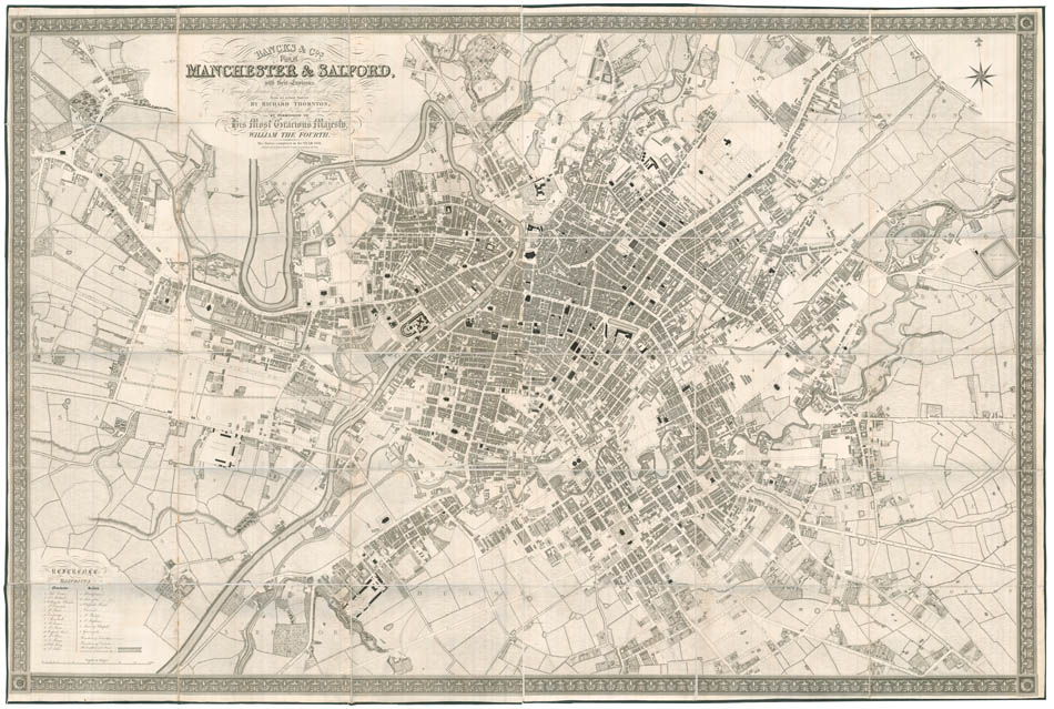
Bancks & Cos. Plan of Manchester and Salford
Bancks & Cos. Plan of Manchester and Salford
with their Environs showing the division of property and the length of each street from an actual survey by Richard Thornton, commenced under the auspices of His late Majesty and now dedicated by permission to His most gracious Majesty, William the Fourth. The Survey completed in 1831.
Stock Code 93990
Manchester, Bancks & Co, Exchange Street, 1832
We could only trace four copies in institutions: two in WorldCat (Manchester and Cambridge), as well as one in the British Library and one in Chetham Library.
This large-scale plan of the city was published when Manchester became the most productive centre of cotton processing, and later the world's largest marketplace for cotton goods. The city's leading position for textile manufacture earned it the names 'Cottonopolis' and 'Warehouse City'. This map, following the tradition of detailed city wall-map makers – such as Greenwood, for instance – thus testifies to the urban changes the city underwent: new manufactures and warehouses are pictured, as well as worker's accommodations. Very detailed, it pictures every building precisely, and cotton mills, silk mills, vitriol works, dye works and more are referenced, some of them absent from the Swire 1924 map of Manchester.
John (d.1831) and Alexander (1797?-1870) Walker were father and son, two chart makers working as 'J. & A. Walker' in London and Liverpool. Alexander, who was probably in charge of the Liverpool branch, also worked with his two brothers John and Charles, established as 'J. & C. Walker' in London. Both companies worked for the British Admiralty.
A fine, fresh example of this impressive cartographic achievement.
Large engraved plan, dissected and mounted on linen, extending east to west from Salford to Beswick and north to south from Cheetham to Hulme, edged with green silk, folding into grey marbled endpapers. Dimensions: 1260 by 1900mm (49.5 by 74.75 inches). Scale: 1 inch to every 90 yards.
BLMC Maps * 3215.(1.)
Couldn't load pickup availability
Provenance
Provenance
Delivery
Delivery
We offer secure and express delivery on all local and international orders of rare books, maps and prints placed through this website.
About us
About us
Shapero Rare Books is an internationally renowned dealer in antiquarian & rare books and works on paper.
Our Bookshop and Gallery can be found in the heart of Mayfair at 94 New Bond Street, where most of our stock is available to view and on public display.
We exhibit at major international art fairs, including TEFAF (Maastricht and New York), Frieze Masters, Art Miami and Masterpiece London, as well as antiquarian & rare book fairs including New York, Paris, London, Los Angeles, San Francisco and Hong Kong.
Ask us a question
Ask us a question


THE BOND STREET BULLETIN
View all-

Captain Cook's Voyages | The publishing phenomenon
The publishing phenomenon around Captain Cook's Voyages
TravelCaptain Cook's Voyages | The publishing phenomenon
by Tomos NuttThe publishing phenomenon around Captain Cook's Voyages
-

Behind the Door to Room 101
Orwell’s famous adage in joining the working-class cause ‘you’ve nothing to lose but your aitches’ was gloriously ironic for a man with one of the plumiest accents of his age....
LiteratureBehind the Door to Room 101
by Adam BlakeneyOrwell’s famous adage in joining the working-class cause ‘you’ve nothing to lose but your aitches’ was gloriously ironic for a man with one of the plumiest accents of his age....
-

Five Iconic Illustrators Who Transformed Childr...
Meet the illustrators whose distinctive styles helped shape the golden age of children’s books — turning simple stories into unforgettable visual experiences.
Five Iconic Illustrators Who Transformed Childr...
Meet the illustrators whose distinctive styles helped shape the golden age of children’s books — turning simple stories into unforgettable visual experiences.


